Posts

Showing posts from May, 2015

Planet Earth - When humans finally dominated Earth .... perhaps the year 1610?

Image
Researchers suggest the geological epoch known as the  Anthropocene  probably began around the year 1610. Scientists say that humans have become a 'geological power'. They suggest that humans have produced a new geological epoch. The key markers for 1610 were - 1 - an unusual drop in atmospheric carbon dioxide, and  2 - the irreversible exchange of species between the New and Old Worlds, according to  new research  published in  Nature . The drop in CO2 was caused by colonisation of the " New World "....North and South America. That event led to the deaths of about 50 million indigenous people , most within a few decades of the 16th century, due to smallpox.  Yes, 50 million people ..... The sudden collapse of farming across the Americas, and the re-growth of Latin American forests, removed enough carbon dioxide from the atmosphere to produce a drop in CO2. Humanity had become a force of nature.

Planet Earth - El Nino

Image
El Niño is an  oscillation of the ocean-atmosphere system in the tropical Pacific , and has important consequences for weather around the world. El Niño happens every three to seven years. “El Niño” is Spanish for “The Christ Child”. Peruvian fishermen named the event many years ago. They noticed that every few years around Christmas, virtually no fish could be found in the unusually warm waters.  El Niño is marked by  unusually warm ocean temperatures  in the Equatorial Pacific. The opposite conditions are called  La Nina , characterized by  unusually cold ocean temperatures  in the Equatorial Pacific.  El Nino clearly affects global temperatures. Information about El Nino is provided in bulletins produced by the US National Weather Service  and the Australian Bureau of Meteorology.

Planet Earth - The End-Permian Mass Extinction

Image
Five major  mass extinction  events are recorded in the rock record of the last 600 million years. The biggest extinction was at the end of the  Permian , around 252 million years ago. It is called the  End-Permian mass extinction. Only about 8% of species survived to live on in the Triassic Period. Geologists investigating tilted sedimentary rocks at Shangsi in South China. Triassic rocks (at the top right) lie over the older Permian rocks. The event played out over 60,000 years. Acidification of the oceans  lasted for about 10,000 years. Two separate pulses of CO2 into the atmosphere - a "one-two punch" - may have been involved in the die-off, according to  new research. CO2 was released by massive volcanism from the  Siberian Traps , now represented as a large region of volcanic rock.  The research team, led by  Dr Matthew Clarkson  from the University of Edinburgh, examined rocks in the United Arab Emirates.  The rocks,  which

Planet Earth - Ammonites

Image
Ammonites  are an extinct group of sea creatures. They were cephalopod molluscs, related to squid and octopus. They are found as fossils, formed when the shells of the animals became buried in sediment which later solidified into rock. The oldest ammonite fossils are found in  Jurassic  rocks, from around 200 million years ago.  They became extinct at the end of the  Cretaceous  around 65 million years ago. Ammonites had shells made of chambers. The air in the chambers helped them to swim. There are hundreds of types of ammonites, with  different shapes. Here are just a few examples.

Planet Earth - The Discovery of the Dinosaurs

Image
In 1822,  Mary Mantell  was looking at rocks alongside a country lane in Sussex, England. She noticed something odd in the rocks. Her husband, Doctor Gideon Mantell, was visiting a patient nearby, and they took the rocks home. Gideon and Mary Mantell The teeth Mary Mantell had found were like those of an iguana, a well-known lizard, but much larger. Doctor Mantell chose the name  Iguanodon   for the animal which had once owned the teeth. Over the next twenty years various other ancient bones and teeth were linked to giant land-living reptiles. In 1842 Richard Owen, superintendent of the Natural History Museum in London, called these animals  dinosaurs. At first, not many full skeletons were found, so rebuilding dinosaurs was difficult. Richard Owen thought  Iguanodon  looked like this model, made in the 1850s. Lots of fossils have been found since, which makes it easier to see a better idea of this amazing animal.

Planet Earth - Greenland

Image
The invention of the name  Greenland  may mark the start of the advertising industry. One story tells how  Erik the Red , the Icelandic Viking who wanted to get people to join his planned settlement, called it Greenland because a pleasant name would attract more settlers. The  ice sheet  on Greenland covers most of this huge island. Each summer the ice surface melts in places, but the area where melt happens is increasing over time. Greenland is losing ice, and the mass of ice lost is measured by satellites called Grace. Updates about Greenland's ice sheet are regularly posted by the National Snow and Ice Data Center.

Planet Earth - Icthyosaurs

Image
Life restoration of  Ichthyosaurus anningae . Image credit: James McKay. A remarkable discovery in the fossil collection of the Doncaster Museum and Art Gallery has led to the naming of a new species.   Ichthyosaurus anningae Picture Credit: Dean Lomax and Judy Massare The name honours Dorset fossil collector  Mary Anning . It was Mary, along with her brother Joseph, who found the first  Ichthyosaurus  fossils to be scientifically studied in 1811. Until now, no species of Ichthyosaurus has been given her name, so this is long overdue. Dean Lomax, Honorary Scientist at The University of Manchester, examined the specimen in 2008.   Working with Professor Judy Massare of Brockport College, New York, Dean spent over five years comparing the Doncaster Ichthyosaur with other museum specimens from around the world.

Planet Earth - Tropical storms

Image
Hurricanes, cyclones, and typhoons are all the same weather phenomenon; we just use different names for these  tropical storms  in different places.  In the Atlantic and Northeast Pacific, the term  “hurricane”  is used, in the Northwest Pacific it is a  “typhoon” , and  “cyclones”  occur in the South Pacific and Indian Ocean. Tropical storms  can’t form outside the tropics - water temperatures are too cold. Sea surface  temperature  must be at least 27 ° C , and this temperature is actually required to a depth of at least 50  m .  The warm tropical atmosphere heats up the water at the ocean surface and begins to  evaporate  it.  The trapped water vapour in the air  rises up  through the atmosphere.  When the rising air cools, and the water vapour  condenses  into liquid water, t he heat is  released  back into the atmosphere. The warm air rushes  upward , because it has a  lower density  than its surroundings.  This then draws air up from below, and speeds up the rising ai

Planet Earth - Intrusive & extrusive igneous rocks

Image
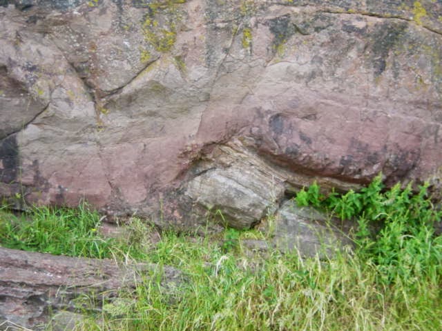
There is a famous rock face just below Salisbury Crags in Holyrood Park,  Edinburgh . The rock face tells us about the hot volcanic past in Scotland. It's called " Hutton's Section " after  James Hutton  who first noticed it. The pale layered rock is broken and tilted by the reddish-brown massive rock. Hutton realised the reddish-brown rock must have been  molten magma , pushing with force into the older  sedimentary rocks . This is an example of an intrusion. The reddish-brown rock is a variety of igneous  rock called dolerite. Edinburgh sits on an ancient volcanic centre.      The volcanic activity happened in the  Carboniferous Period. In this view,  Salisbury Crags  palisade stands over the city - it is a sill . On the right is  Arthur's Seat , made of four eroded central volcanic vents. This diagram explains how some  volcanic landforms  are made. A sill is one type of igneous intrusion. Fingal's Cave  is on Staffa, an island nea

Planet Earth - Fossil footprints

Image
Footprints of many kinds of creatures have survived as fossils in rocks. This can be because they were quickly covered by volcanic ash, or layers of fine clay, preserving the details. These footprints were most likely made by  Australopithecus afarensis , an early human whose fossils were found in the same sediment layer. They were found at Laetoli in Tanzania. The Smithsonian Museum has a wonderful site about footprints found at Laetoli. Looking at much older rocks, footprints of dinosaurs can be used to find out all sorts of things about their lives. There are plenty of dinosaur tracks in Texas, for example . Dinosaur footprints can make an   interesting educational activity.

Planet Earth - The Polar Regions

Image
The Earth's poles are warming faster than the rest of the planet. One reason is that energy is carried to the poles by large weather systems. The  Arctic   includes an  ocean covered by sea ice . Arctic sea ice  melts in Summer and then refreezes in Winter. The area of Arctic sea ice is largest in March each year, and at its lowest each September. It is reducing over time - the graph comes from the US  National Snow and Ice Data Center. Research suggests   the remarkable decline of   Arctic sea ice over  the last century is far beyond anything seen for a long time.   The  Antarctic  is a  continent covered by ice , unlike the ocean in the Arctic. The sea ice surrounding Antarctica melts almost to the coast each summer. The winter sea ice has increased by around 1 % over the last few decades. This is due to complex processes. It is linked to  melting of the land ice on Antarctica ….. Here is an outline  of what is happening in the seas ar

Planet Earth - Iceland, a land of ice & volcanoes

Image
Iceland lies on the  Mid-Atlantic Ridge , which is why it has volcanic activity. Iceland also has  ice caps  and  glaciers . Iceland is one of the fastest-warming places on the planet  – as much as four times the Northern Hemisphere average.  The glaciers that cover more than 10% of the island are losing an average of 11 billion tonnes of ice a year.                 Iceland glacial meltwater - photo Tom Harding The water melting from Iceland's glaciers would fill 50 of the world's largest trucks every minute for the entire year. Parts of Iceland are rising as the ice caps melt,  reducing the weight on the Earth's crust. The thinning of the ice caps reduces the pressure on the rocks. Geologists know reduced pressure from above makes volcanoes erupt more easily. Lower pressure allows volcanic gases to expand, and mantle rocks melt more easily at lower pressure as well. This means more magma can rise into the volcanic systems. Iceland's volcanoes ma

Planet Earth - Ancient desert sandstones

Image
Some sandstones have very obvious sweeping curved patterns within their layers. This sandstone dates from the  Permian period , and is in south Devon. This pattern is called cross-bedding . It is formed when loose sand is moved, sometimes by water and sometimes by wind. This larger sized cross-bedding is more often linked to wind movement, but to be sure geologists look closely at the sand grains. The grains are mostly rounded off , not sharp, which shows they were blown by the wind. This suggests that the sandstone was produced in a desert . The cross-bedding forms as sand flows down the front of sand dunes. Another well-known cross-bedded sandstone is the  Coconino Sandstone , seen in the Grand Canyon . It is another Permian rock, formed in a desert.

Planet Earth - Caves, Stalactites and Stalagmites

Image
Speleothems  are cave features formed by  minerals.  The word  speleothem  comes from the Greek words  spelaion  meaning "cave" and  thema  meaning "deposit".  The most well-known speleothems are  stalactites  and  stalagmites .  Stalactites grow down from the cave ceiling. Stalagmites grow up from the cave floor.  It’s easy to remember which is which:  Stalactites have a "T" for top and stalagmites have a "G" for ground. Caves, stalactites and stalagmites are caused by chemical reactions .

Planet Earth - Geothermal Heat in Antarctica

Image
There have been very inaccurate stories on various websites claiming ...... "Volcanoes are the main reason for ice melting in Antarctica." This is not the case. The story is mainly a misreading of research on the  Thwaites glacier . This is the actual paper about this research...... "Evidence for elevated and spatially variable geothermal flux beneath the West Antarctic Ice Sheet"                So what actually  is  happening?  The Thwaites Glacier is behaving more like a  warm-based glacier . Warm-based glaciers are usually found in temperate regions like the Alps. Most polar glaciers are  cold-based glaciers . The  geothermal heat  from under the Thwaites glacier is small compared to the overall warming happening around Antarctica. The Thwaites Glacier is one of a number of glaciers in that part of Antarctica. “It is true that there are active volcanoes in West Antarctica, and so there may have been some local changes, but i