Interesting Scientists - Fred Shotton and the D-Day Beaches
In June 1944, a vast army of troops from Britain, the USA, Canada, France and other countries landed on beaches in northern France to begin the push to remove Adolf Hitler's forces from France.
There were many secret preparations but one vital part of the story was the Shotton Map....
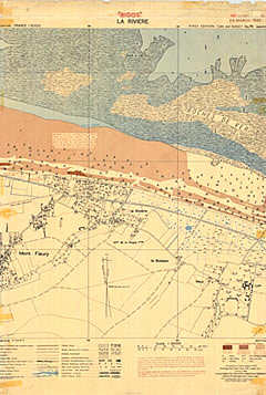
Starting in the October of 1943, a team including geologist Fred Shotton worked to produce detailed geological maps of all the beaches in the area, to help choose the invasion beaches.
Shotton took part in secret flights to observe the beaches, using a special glass-bottomed aircraft.
Special forces teams were sent on very dangerous missions to swim ashore at night to collect samples of sand from the beaches, so that they could be analysed by the geologists.

Fred Shotton became Professor of Geology at the University of Birmingham in central England.
He became an expert in the study of the 'Ice Age'.

There were many secret preparations but one vital part of the story was the Shotton Map....
Starting in the October of 1943, a team including geologist Fred Shotton worked to produce detailed geological maps of all the beaches in the area, to help choose the invasion beaches.
Shotton took part in secret flights to observe the beaches, using a special glass-bottomed aircraft.
Special forces teams were sent on very dangerous missions to swim ashore at night to collect samples of sand from the beaches, so that they could be analysed by the geologists.
Fred Shotton became Professor of Geology at the University of Birmingham in central England.
He became an expert in the study of the 'Ice Age'.


